
National Conditions: March 22, 2023 - March 28, 2023
The trend continues: Most of the West, Northern Plains, and Midwest are seeing steady improvement. Meanwhile, the Southern Plains (particularly Texas), Florida peninsula, and Mid-Atlantic/Southeast Coast are worsening.
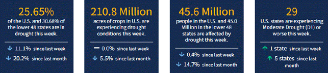
As of March 28, 2023, 25.65% of the U.S. and Puerto Rico and 30.68% of the lower 48 states are in drought, according to the U.S. Drought Monitor.
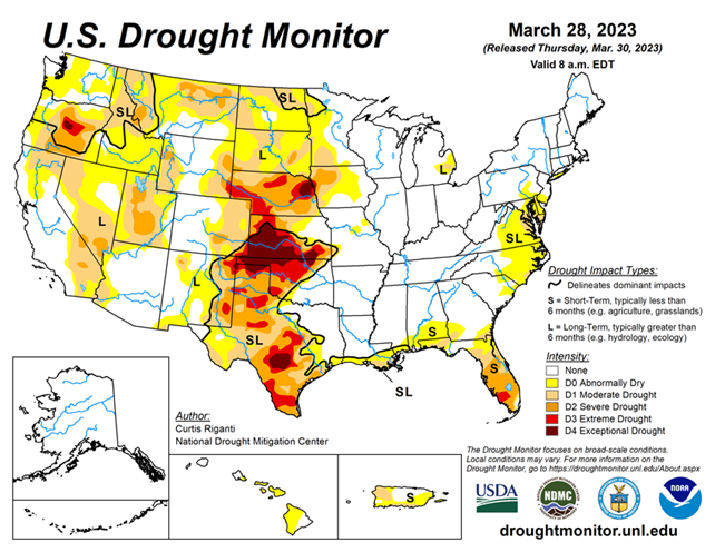
This Week's Drought Summary...
After the wet pattern continued in parts of the West this week, building off of widespread wet and snowy weather this winter, widespread improvements were made to the drought depiction, especially in northern California, northern Nevada, southern Idaho and Utah, with scattered changes, mostly improvements, also taking place in other western states. East of the Rockies, drought and abnormally dry conditions mostly stayed the same or worsened in the Texas and Oklahoma panhandles, northwest Oklahoma, and central and southeast Texas.
The western edge of heavy rains this week fell mostly along and southeast of the Interstate 44 corridor in Oklahoma and western north Texas, leading to further tightening of an already tight drought condition gradient in these areas. Farther west in northwest Oklahoma and western Kansas, extreme and exceptional drought persisted or intensified. Very dry recent weather continued in the Florida Peninsula, where severe drought expanded in coverage and extreme drought developed in response to quickly increasing fire danger. In the Mid-Atlantic, short- and long-term drought and abnormal dryness grew a bit in coverage this week. Conditions also worsened in northwest Puerto Rico and the southern Puerto Rico coast, the latter of which reported nearby forest fires. For more specific details, please refer to the regional paragraphs below.
Looking Ahead...
From the morning of Wednesday, March 29 through the evening of Monday, April 3, the National Weather Service Weather Prediction Center is forecasting precipitation in some of the higher elevation areas of California, with heavier amounts likely in western Oregon and Washington. Some mountainous areas of Idaho, Colorado, southwest Montana, Wyoming and Utah will likely see over 0.75 inches of precipitation, with some locally heavy amounts possible. Farther east, the southern Great Plains are likely to remain dry, while precipitation is likely from South Dakota into the Upper Great Lakes, and from the Lower Great Lakes southwest toward the Lower Mississippi Valley as a strong storm system traverses the central Great Plains and Midwest. Localized precipitation amounts at or exceeding 0.75 inches are possible for northeast New York and Vermont as well.
From April 4-8, the National Weather Service Climate Prediction Center forecast strongly favors colder-than-normal weather in the West and warmer-than-normal conditions in the Southeast, with the dividing line between warmer and colder than normal running from Chicago southwest to St. Louis southwest to the Texas Big Bend region. Northwest of this line, below-normal temperatures generally become more likely, with the opposite true southeast of this line. Below-normal temperatures are slightly favored in much of Alaska, especially in the southeast regions. Above-normal precipitation is favored across much of the contiguous U.S., excluding the Florida Panhandle, western Montana, southern Arizona, New Mexico, and the El Paso area. The highest confidence for above-normal precipitation for this time period is over South Dakota, North Dakota and Minnesota. Wetter-than-normal weather is also favored in Alaska.