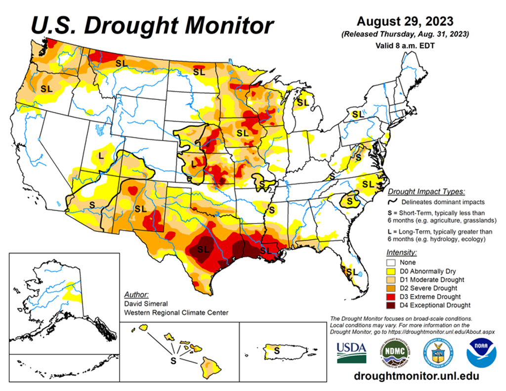
National Current Conditions: August 23, 2023 - August 29, 2023
While parts of Florida and the Southeast are experiencing flooding from Hurricane Idalia, drought worsened from New Mexico across to Louisiana and in the Upper Midwest. Extreme Drought (D3) also developed/expanded in Montana, North Dakota, and Kansas.
As of August 29, 2023, 28.76% of the U.S. and Puerto Rico and 34.28% of the lower 48 states are in drought, according to the U.S. Drought Monitor.


This Week's Drought Summary...
This U.S. Drought Monitor (USDM) week saw continued intensification of drought across areas of the Midwest, South, Southwest, and the Pacific Northwest. In the Midwest, extreme heat impacted areas of the region including Minnesota, Iowa, Missouri, Wisconsin, and Illinois with temperatures soaring 6 to 10+ degrees F above normal. Daily high temperature records were broken across the region during the past week including in Chicago (98), Milwaukee (101), Minneapolis (101), and Des Moines (100). Similarly, areas of the South including the northern Gulf Coast of Texas, Louisiana, and southern Mississippi saw continued drought-related deterioration on this week’s map as the heatwave continued to push high temperatures over 100 degrees F with numerous records broken during the past week. Record daily highs were set or tied in various southern cities including Houston (109), San Antonio (104), Austin (107), Dallas (109), Baton Rouge (106), New Orleans (103), Jackson (106), and Mobile (101). In Louisiana and southern Mississippi, the continued hot and dry conditions have led to numerous wildfire outbreaks as well as widespread poor hydrologic conditions and severe impacts within the agricultural sector.
In the Southwest, monsoon precipitation has been well below normal across much of the region with areas of southern Arizona and New Mexico reporting rainfall deficits ranging from 3 to 6 inches since the beginning of July. In the Pacific Northwest, areas of drought expanded on the map in Oregon, Washington, and Montana in response to a combination of above-normal temperatures over the past 90-day period, precipitation shortfalls, and poor surface water conditions. Conversely, some areas saw improved drought-related conditions on the map, including southern Texas where heavy rains, in association with Tropical Storm Harold last week, provided much-needed moisture to the region. Rainfall accumulations along the southern Gulf Coast and South Texas Plains regions ranged from 2 to 6 inches. In the Southeast, areas of Florida braced themselves for the impacts of Hurricane Idalia as it intensified rapidly early this week. The hurricane made landfall in the Big Bend region of Florida early Wednesday morning (8/30) as a dangerous Category3 hurricane bringing a life-threatening storm surge, catastrophic winds, and severe flooding.